Dawlish Tourist Information Centre
The Brunel Trail
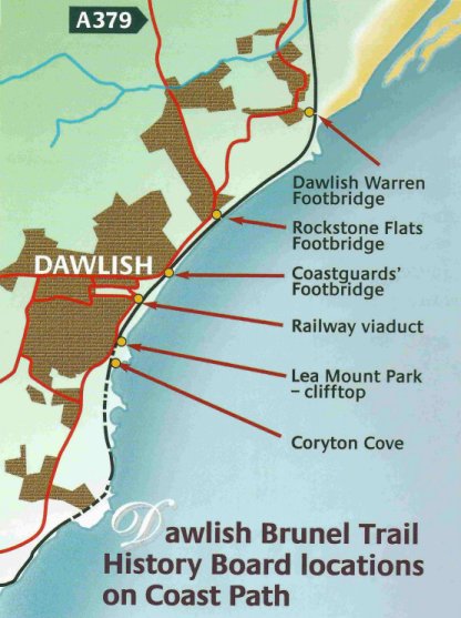
The Brunel Trail is a series of history boards, placed along the coastal path between Coryton Cove and the footbridge at Dawlish Warren, describing the history of the town and coastline in the period of change in the middle of the 19th century when railways were developing.
They are placed approcimately 10 to 15 minutes walk apart, with a slightly longer interval from Rockstone to the Warren footbridge.
At Coryton Cove the board describes the geology of the coast and the red sandstone rolling cliffs that have eroded into weird rock forms. Brunel proposed to run the railway much further out from the cliffs and to blast sections of the cliff to reduce the need for tunnels. This would have destroyed many of the coves along the coast. Luckily for us, there were many objections at the time, and so the route was modified to tunnel through the cliffs.
At Lea Mount, the board shows how Dawlish appeared in the early years of the 19th century. The location was a viewpoint for many early prints of Dawlish as it provides a good general view of Westcliff, the town and coast. A sequence of views from this location show the gradual spread of housing onto higher ground, giving good sea views, and the appearance of the railway separating the town from its beach.

At the Viaduct the board sets out the case of Brunel's family and his key collaborators in the development of the South Devon Railway. It describes how there was an influx of workers to the town and how much of the property along the parade was purchased and used as offices and later resold.
At Coastguards approach, the board describes the many casualties that were in the line of the new railway, and shows how the railway overthrew the recent turnpike route into central Dawlish and turned it to its own advantage, but to our considerable inconvenience.
The sea wall contains mainly limestone and granite in its construction. At Rockstone the board describes the labour and materials needed for its construction, and the similarity of the methods to those used in building canals in the previous century.
The northern end of the trail (at present) is the pair of boards mounted by the old footbridge over the railway at Dawlish Warren. From here it is possible to look up to the track to Starcross and see the old pumping station to the atmospheric railway. The material describes that innovative enterprise, that ran for seven months under atmospheric pressure alone.


